The Pan-American Highway gets billed as the world’s longest drivable road, stretching about 19,000 miles (30,600 kilometers) from Prudhoe Bay, Alaska, to Ushuaia, Argentina. Tip to tip, it crosses 14 countries, linking North, Central, and South America—except for the tricky Darién Gap in Panama, where a 60-mile jungle stretch forces a ferry detour. Exact traveler numbers stay tough to pin down, but thousands tackle parts of it yearly—some estimate 1,000-2,000 brave the full route annually, from overlanders to cyclists. Fun facts? It hits 11,322 feet at Costa Rica’s Cerro de la Muerte, and cyclist Carlos Santamaría set a Guinness record in 2018, pedaling it in 117 days. In Ecuador, this epic road—called Highway 35 or “La Panamericana”—slices through the Andes, offering a wild mix of mountains, markets, and history.
Where It Starts: Tulcán in the North
The Pan-American Highway in Ecuador kicks off at Tulcán, right on the Colombian border. This northern gateway sits in Carchi Province, about 2,950 meters (9,678 feet) up in the Andes. The Rumichaca Bridge marks the crossing point—Colombia’s Highway 25 hands off to Ecuador’s Highway 35 here. Tulcán’s a small city, home to around 60,000 people, and it’s got a chill, highland vibe.
First stop? The Tulcán Cemetery gets visited for its mind-blowing topiary art. Shrubs get trimmed into arches, animals, and faces—some call it a “living sculpture garden.” It’s free to wander, and the craftsmanship stuns. Nearby, the El Ángel Ecological Reserve tempts with its frailejón plants—fuzzy, high-altitude oddities—and rolling páramo landscapes. So, Tulcán sets the tone: rugged nature meets quirky charm.
Heading South: Ibarra, Cotacachi, Otavalo, and Volcanic Wonders
From Tulcán, the highway rolls south 120 kilometers to Ibarra, the capital of Imbabura Province. This stretch of the Pan-American Highway in Ecuador winds through green valleys and past small farms. Ibarra, with about 131,000 residents, gets nicknamed “The White City” for its colonial buildings painted in pale hues. San Miguel de Ibarra’s historic center gets explored for its cobblestone streets and old churches—like the Catedral de San Miguel Arcángel. A short detour off the highway leads to San Antonio de Ibarra, where wood carvings get crafted by local artisans.
Just 25 kilometers south of Ibarra, Cotacachi pops up along the route. This small town, home to 8,000, gets known for leather goods—shops line the streets with handmade bags and jackets. The nearby Cuicocha Crater, a 15-minute drive west, stuns with its turquoise lake inside a volcanic caldera. Boats get rented to circle its two islands, or trails get hiked for jaw-dropping views at 3,246 meters (10,650 feet). It’s a quiet gem worth a stop.
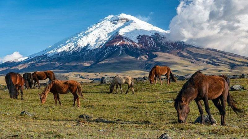
Next, 20 kilometers south of Ibarra, Otavalo rolls into view. Famous for its massive Saturday market, this town of 40,000 buzzes with Kichwa vendors. Textiles, ponchos, and jewelry get sold—prices haggle down if you’re savvy. The Plaza de los Ponchos gets packed, even on weekdays, with colorful stalls. Want nature? Imbabura Volcano looms nearby at 4,630 meters (15,190 feet). Trails get hiked for killer views, though it’s a steep climb. Plus, Laguna San Pablo sits 15 minutes away—perfect for a quick boat ride or just soaking in the scenery.
Further along, 60 kilometers south of Ibarra toward Quito, Cayambe Peak towers at 5,790 meters (18,996 feet). This snow-capped giant, just off the highway, gets climbed by pros or admired from below. The town of Cayambe, with 39,000 people, gets passed through too—stop for bizcochos (buttery biscuits) and cheese. So, this stretch from Ibarra through Cotacachi, Otavalo, and Cayambe blends culture, crafts, and epic volcanic sights seamlessly.
Quito: The Capital Stop
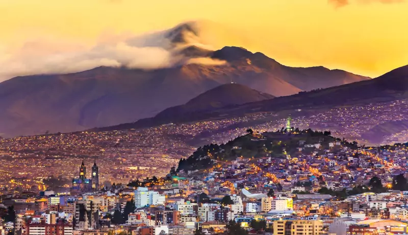
Next up, the Pan-American Highway in Ecuador hits Quito, 115 kilometers south of Ibarra. At 2,850 meters (9,350 feet), this capital city—population 2 million—ranks as the world’s second-highest capital after La Paz, Bolivia. Highway 35 cuts right through, splitting into “Panamericana Norte” and “Panamericana Sur” as it passes.
Quito’s Old Town, a UNESCO World Heritage site, gets packed with colonial gems. The Basilica del Voto Nacional towers with its gothic spires—climb it for panoramic shots. Plaza Grande buzzes with locals, and the San Francisco Church stuns with gold-leaf interiors. Outside the city, the Mitad del Mundo monument marks the equator—stand in both hemispheres at once. For nature buffs, Pichincha Volcano’s Rucu Pichincha peak gets reached via a cable car and hike. So, Quito’s a must-stop for history and highland thrills.
Latacunga and Cotopaxi’s Majesty
South of Quito, 90 kilometers down the Pan-American Highway in Ecuador, Latacunga rolls into view. This city in Cotopaxi Province, home to 51,000, sits at 2,760 meters (9,055 feet). It’s a quieter spot, but the highway keeps it connected.
Cotopaxi National Park steals the show here. Just off Highway 35, Cotopaxi Volcano—5,897 meters (19,347 feet)—gets admired as one of the world’s highest active volcanoes. Trails get trekked to its base, or refuges at 4,800 meters if you’re gutsy. The park’s Limpiopungo Lagoon reflects the peak on clear days—great for photos. In town, Latacunga’s Mama Negra festival in November gets celebrated with parades and wild costumes. Thus, this stop mixes volcanic awe with local flavor.
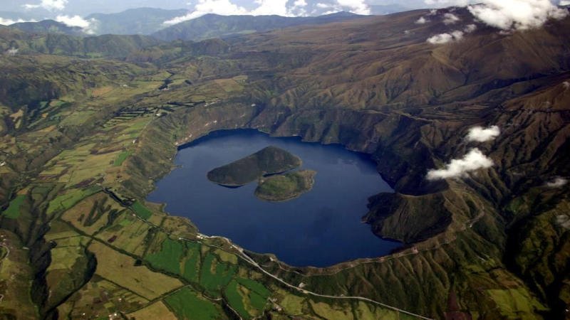
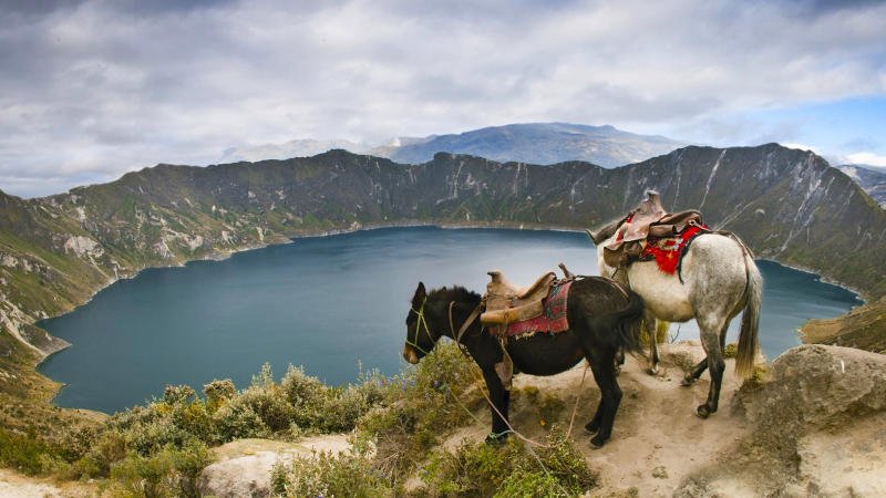
A must-see detour, Quilotoa Crater Lake, sits 50 kilometers west of Latacunga. This stunning turquoise lake fills a volcanic caldera at 3,914 meters (12,841 feet)—a 45-minute drive off the highway. Trails get hiked down to the water in about 30 minutes, or mules get ridden back up if your legs tire. Kayaks get rented for a paddle across its eerie, mineral-rich surface. Locals sell crafts at the rim, and the view—especially at sunrise—drops jaws. So, Quilotoa’s a jaw-dropping add-on to this highway stretch.
Ambato: Fruit and Festivals
From Latacunga, the Pan-American Highway in Ecuador rolls 50 kilometers south to Ambato, in Tungurahua Province. This city of 165,000 sits at 2,577 meters (8,455 feet). Known as the “Garden of Ecuador,” Ambato thrives on fruit and flowers, thanks to its mild climate. The highway hums through, linking it to the Andean chain.
The Fiesta de las Flores y las Frutas in February gets packed with parades and fruit displays—think floats made of apples and roses. The Juan Montalvo House Museum honors the local writer with a peek into his life. Nearby, Tungurahua Volcano (5,023 meters, 16,479 feet) gets watched—it’s active, so check conditions. The Quinta de Mera, a botanical estate, tempts with orchids and quiet trails. Therefore, Ambato’s a tasty, colorful stop on this Ecuador road trip.
Riobamba: Chimborazo’s Shadow
Another 50 kilometers south, the Pan-American Highway in Ecuador reaches Riobamba, the capital of Chimborazo Province. With 146,000 people, it sits at 2,754 meters (9,035 feet). The Andes frame it, and the highway cuts through its eastern edge.
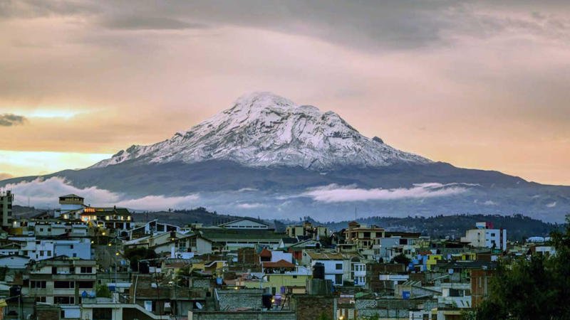
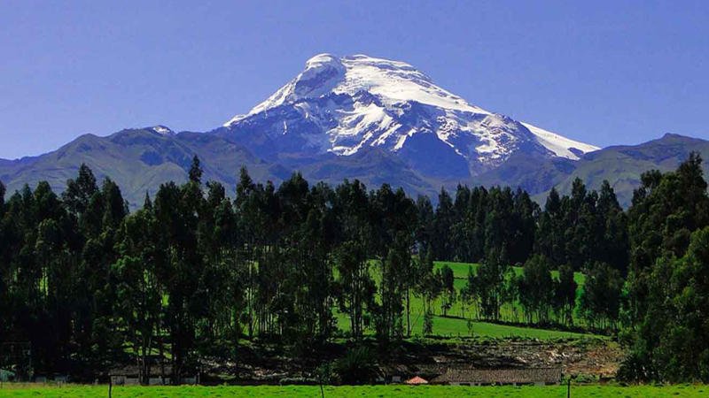
Chimborazo Volcano, 6,263 meters (20,548 feet), sits 30 kilometers west of Riobamba. It’s Ecuador’s tallest peak and—cool twist—the farthest point from Earth’s center, thanks to the equatorial bulge. That doesn’t make it the highest spot on Earth by height, though—Everest still wins there—but it’s the closest you can stand to outer space! Summits get attempted by pros, but day trips to its base amaze too. In Riobamba, the Saturday market gets browsed for Kichwa textiles and fresh produce. The old train station—once part of a Quito-to-coast line—offers a history hit. So, Riobamba’s a gateway to big nature and small-town life.
Cuenca: Colonial Charm
Further south, 246 kilometers from Riobamba, the Pan-American Highway/hwy 35 in Ecuador nears Cuenca—though it skirts the city’s edge. In Azuay Province, Cuenca’s 330,000 residents live at 2,560 meters (8,399 feet). It’s a UNESCO World Heritage site for its colonial core.
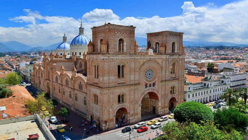
Cuenca’s Catedral Nueva, with its blue domes, gets photographed a ton. The Pumapungo Ruins tie back to Inca days—free to visit, with a museum attached. The Tomebamba River cuts through, perfect for a stroll. A detour to Cajas National Park, 30 kilometers west, offers misty lakes and hiking at 4,000 meters (13,123 feet). So, Cuenca’s a blend of history and highland beauty.
Loja: The Southern Gem
The Pan-American Highway in Ecuador winds 200 kilometers south from Cuenca to Loja, the capital of Loja Province. With 180,000 people, it sits at 2,225 meters (7,300 feet). The highway’s path gets twistier here, hugging the Andes.
Loja’s known for music—street performers fill the air. The Puerta de la Ciudad, a castle-like gate, welcomes visitors. Podocarpus National Park, 14 kilometers south, gets explored for its cloud forests and rare birds—think toucans and Andean cocks-of-the-rock. The Vilcabamba Valley, 40 kilometers away, gets dubbed the “Valley of Longevity” for its chill vibe and healthy locals. Thus, Loja’s a cultural and natural treat.
Where It Ends: Macará in the South
The Pan-American Highway in Ecuador wraps up at Macará, 130 kilometers south of Loja, on the Peruvian border. This small town in Loja Province, with about 20,000 people, sits at 450 meters (1,476 feet)—way lower than the northern highlands. Highway 35 ends at the Macará International Bridge, linking to Peru’s Highway 1N.
Macará’s quieter, but its rice fields and warm climate stand out. The nearby Puyango Petrified Forest gets visited for fossilized trees from 100 million years ago—pretty wild stuff. It’s a 40-minute drive off the highway. The border market buzzes with traders swapping goods. So, Macará’s a low-key finale with a prehistoric twist.
Major Cities and Sights Along the Way
The Pan-American Highway in Ecuador—Highway 35—strings together some big hitters. Tulcán, Ibarra, Quito, Latacunga, Riobamba, Ambato, Cuenca, Loja, and Macará mark the route, each with its own pull. Quito’s the star, with its colonial heart and equator line. Cuenca charms with old-world streets. Riobamba and Latacunga flex volcanic giants—Chimborazo and Cotopaxi.
Things to see? Volcanoes dominate—Imbabura, Cotopaxi, Chimborazo, Tungurahua. Parks like Cajas and Podocarpus dazzle with lakes and wildlife. Markets in Otavalo, Riobamba, and Ambato burst with color. Otavalo’s massive outdoor market—the biggest in Ecuador—draws crowds with Kichwa textiles and crafts. History hits hard in Quito and Cuenca, while Tulcán’s cemetery and Macará’s fossils add quirks. Thus, the highway’s a jackpot for road trippers.
Why Drive the Pan-American Highway in Ecuador?
This stretch of the Pan-American Highway in Ecuador covers about 700 kilometers north to south. It’s not the whole 19,000-mile beast, but it packs a punch. The Andes get showcased—snowy peaks, green valleys, and tiny towns. Culture gets layered on thick, from Kichwa markets to colonial plazas.
Driving it takes 12-15 hours straight, but why rush? Stops at volcanoes, ruins, and festivals stretch it into days. Costs stay low—gas hovers at $2.50 a gallon, and roadside eats like maito (grilled fish in leaves) run $3-5. Risks? Twisty roads and altitude need respect, but it’s paved and solid. So, for an “Ecuador road trip” that hits nature, history, and local life, this highway’s your ticket.