Exploring Quilotoa Ecuador: A Jewel in the Andes
Nestled high in the rugged Ecuadorian Andes, Quilotoa Ecuador is a breathtaking destination that captivates adventurers, nature lovers, and curious travelers alike. This stunning crater lake, formed within the caldera of the Quilotoa volcano, offers a mesmerizing blend of natural beauty, cultural richness, and thrilling outdoor activities. From its vibrant turquoise waters to its challenging hiking trails, Quilotoa is a must-visit spot in Ecuador that promises an unforgettable experience. Let’s dive into the fascinating details of this Andean gem, uncovering its facts, trails, and unique allure.
The Quilotoa Crater Lake: A Geological Marvel
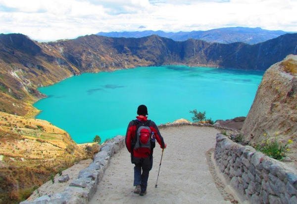
Quilotoa Lake sits within a massive caldera, a testament to the explosive power of nature. About 800 years ago, in what is known as the 1280 Plinian eruption, the Quilotoa volcano unleashed a catastrophic VEI-6 event—among the most powerful volcanic eruptions possible. The eruption was so forceful that it caused the volcano to collapse in on itself, forming the 3-kilometer-wide (1.86-mile) crater we see today. Over time, this depression filled with water, creating a lake that plunges to a depth of 250 meters (820 feet). The lake’s striking greenish-turquoise hue comes from dissolved volcanic minerals, and beneath its surface, fumaroles—volcanic gas vents—bubble quietly, hinting at the geological activity still simmering below.
The water in Quilotoa Lake is notoriously cold, averaging around 5-10°C (41-50°F) year-round, due to its high altitude and the chilly Andean climate. Swimming is technically allowed, but the frigid temperatures, combined with the lake’s steep drop-offs and mineral content, deter most visitors from taking a dip. Locals and experts often discourage it, citing both the cold and potential health risks from prolonged exposure to the volcanic minerals.
Hiking the Quilotoa Crater Rim
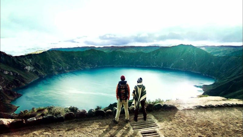
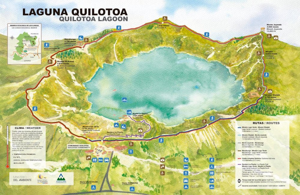
One of the most popular activities at Quilotoa is hiking the trail that encircles the crater rim. This loop trail stretches approximately 10.5 kilometers (6.5 miles) and offers jaw-dropping panoramic views of the lake and the surrounding Andean landscape. The hike typically takes 4 to 6 hours to complete, depending on your pace, fitness level, and how often you stop to soak in the scenery or snap photos. The trail is considered moderate to challenging, not because of its length but due to the high altitude and undulating terrain.
The lake sits at an elevation of 3,914 meters (12,841 feet) above sea level, making it one of the highest crater lakes in the world. At this altitude, the air is thin, and even seasoned hikers may find themselves catching their breath more often. The path climbs and dips repeatedly, with some steep sections and narrow ridges that demand careful footing. The soft, sandy soil can be slippery, especially in wet conditions, so sturdy hiking shoes are a must. Weather adds another layer of adventure—mornings often start clear, but fierce winds and clouds can roll in by afternoon, dropping temperatures and visibility. Packing layers and starting early are key to a successful hike.
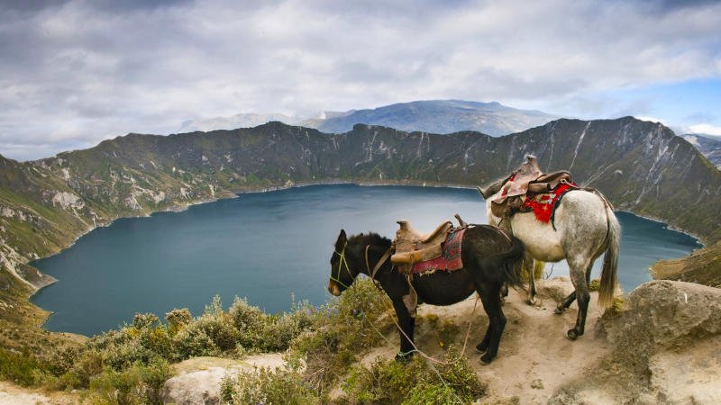
For those seeking a shorter trek, a 2.2-mile round-trip trail descends from the rim to the lake’s edge. This steep, sandy path takes about 20-30 minutes to go down and 45-60 minutes to climb back up, depending on your stamina. At the bottom, you’re rewarded with an up-close view of the lake’s ethereal waters—a perfect spot for reflection (literal and figurative).
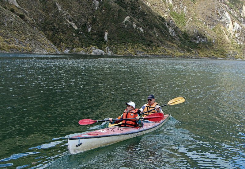
Activities on the Lake
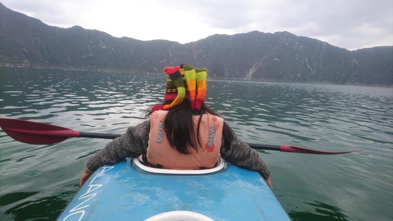
Once you reach the lakeshore, a few unique activities await. Kayaking is a favorite, with rentals available for around $2-3 USD per hour. Paddling across the lake offers a serene way to appreciate its vastness and the steep crater walls towering above. The water’s stillness, interrupted only by the occasional ripple from volcanic gases, creates an otherworldly atmosphere. Canoes are sometimes available too, though options depend on local vendors. Camping is permitted near the shore, but there’s no potable water beyond small bottles sold at a basic hostel, so plan accordingly.
Location and Accessibility
Quilotoa lies in Ecuador’s Cotopaxi Province, about 178 kilometers (111 miles) southwest of the capital, Quito. The drive from Quito takes roughly 3 hours along the Pan-American Highway, passing through stunning Andean scenery, including the towns of Tigua and Zumbahua. For those relying on public transport, buses from Quito’s Quitumbe Terminal to Latacunga (a 2-hour ride) connect to onward services to Quilotoa, adding another 1.5-2 hours. The total journey by bus can take 4-5 hours, making it a feasible day trip, though an overnight stay lets you fully savor the experience.
Nearby, Latacunga, 70 kilometers (43 miles) northeast, is the closest significant city and a common base for exploring Quilotoa. Further south, Riobamba (about 130 kilometers or 81 miles away) offers another urban hub, while Baños, a popular adventure town, is roughly 150 kilometers (93 miles) to the southeast. Each provides a gateway to Quilotoa, though Latacunga’s proximity makes it the most practical.
Interesting Facts That Set Quilotoa Apart
Quilotoa is more than just a pretty lake—it’s steeped in history and mystery. The 1280 eruption was so massive that its ash reached the Pacific Ocean, over 200 kilometers away, and blanketed the northern Andes, leaving a lasting mark on the region’s geology. Scientists believe the lake existed in some form even before this event, as earlier eruptions were phreatomagmatic—explosions driven by magma meeting water. Today, hot springs on the volcano’s eastern flank remind us of its restless nature.
Locals report that the lake level has been slowly dropping over the past decade, with travertine deposits—mineral formations—visible up to 10 meters (33 feet) above the current shoreline. This gradual decline adds an air of intrigue: is the lake responding to climate shifts, or is something deeper at play beneath the Andes?
Culturally, Quilotoa is intertwined with indigenous Kichwa communities who live in the nearby village of the same name. Their traditions, from farming to vibrant festivals, enrich the area. The name “Quilotoa” itself, meaning “princess’s tooth” in Quechua, hints at ancient stories lost to time—a poetic nod to the lake’s jagged beauty.
Why Quilotoa Stands Out?
At nearly 4,000 meters, Quilotoa’s altitude alone sets it apart, offering a high-altitude adventure that tests both body and spirit. Its location in the Avenue of the Volcanoes, a stretch of the Andes dotted with peaks like Cotopaxi and Imbabura, places it in one of Earth’s most dramatic landscapes. Yet, despite its grandeur, Quilotoa remains less crowded than other regional hotspots, thanks to its remote setting and winding access roads. On a quiet day, you might hike the rim with only wildflowers, a stray llama, or the wind for company.
For hikers, the Quilotoa Loop—a 40-kilometer (25-mile), multi-day trek through villages like Sigchos and Chugchilán—extends the adventure beyond the crater, blending rugged trails with cultural immersion. Whether you tackle the full loop or stick to the rim, Quilotoa rewards effort with raw, unfiltered beauty.
In a world of polished tourist traps, Quilotoa feels refreshingly wild. It’s a place where nature’s power is palpable, where every step reveals a new perspective, and where the Andes’ timeless majesty shines through. So, lace up your boots, pack your curiosity, and head to Quilotoa—Ecuador’s turquoise treasure awaits.


